رادار التأريض الاحترافي
KS الرادار الأرضي
KS-900
جهاز مدمج مع لوحة
لمس ، وزن منخفض
استخدم في أي تضاريس ، حتى في التضاريس التي يصعب الوصول إليها ،
قوي ومرن
في الحجر الجيري حتى عمق
اختراق يصل إلى 60 مترا الكشف عن المعادن / المعادن
الثمينة الكشف عن التجويف / طبقات التربة / الأنفاق / الآبار / الأنابيب / الكابلات / الأنابيب / الكهوف مجالات
التطبيق: علم الآثار / البحث عن الكنوز / المكاتب الهندسية
كما نقدم حلولا خاصة / تطورات خاصة بالعملاء

KS-800
The KS 800 has a new software programmed with the following advantages: The measurement can be carried out continuously without having to go to the starting point. The recording of the data is saved automatically, you don’t have to press the record button in the software. The measurement is automatically displayed in the measurement image and can be saved. The conversion to 3D display runs automatically and the 3D image can be viewed immediately. The measurement can be saved to an external storage medium and can also be loaded into Voxler. Updates can be installed automatically via an Internet connection. The surface search of smaller materials is advantageous Deep-lying materials are optimally represented.
Antenna: T/R Depth performance: 30-60m (limestone) Battery: Lithium Polymer 15Ah built-in Mobile with trolley Handling on the measuring field of 1 person Shipping: 2 boxes Compact design Foldable (transport) Waterproof and shockproof touchpad 2D and 3D software touchpad USB socket for exporting to USB Improved data processing Resolution 1-6m Max. sampling rate 200 ms/s Buffer-memory 16KS Rise time 14 ns Vertical Resolution 8 bit Timebase ranger 10ns/1s Timebase accuracy +/: 100 ppm Metrics: Height: 26cm without chassis / 1.25cm with chassis Width: 43cm Length: 63cm
With this FMCW ground penetrating radar, there is no need to replace the antenna for different depth ranges!
KS-700
THE KS-700 DOES NOT
NEED DIFFERENT ANTENNAS.
The KS700 has been developed for cavity detection.
It is a ground penetrating radar and works according to the principle of
‘FMCW radar’.
The ground-penetrating radar locates from 0-40 m in the solid rock body.
We have located tunnels from the 2nd World War in limestone up to 60 m, but you have to keep in mind that these tunnels have a size of about 5 m wide and about 7 m high.
Overview
Portable Ground Penetrating Radar
2D On-Site
Analysis 3D On-Site
Analysis Simple Control
Battery Operated
USB Interface
Ready to Use at Any Temperature
Up to 40m Deep Detection
APPLICATIONS
Use in archaeology with metal detection
Investigation of contaminated sites
Underground sounding for construction projects – especially for cables, pipe sounding and shafts
Exclusion of danger in the event of consequential mining damage and sinkholes
Localization of old underground rooms, tunnels, tunnels, old corridors and much more.
THE KS700 GROUND PENETRATING RADAR IS COMPOSED OF
Electronic control unit
, test, mounted antenna shielded in all directions,
power supply: 12V/18Ah
data, 2D and 3D data
visualization, software, operator’s manual,
operator video complete
Software and measurement images Groundradar
The software realizes the immediate display of the measurement image.
The display of the measuring profiles is two-dimensional and enables the user to quickly realize the measurement profile.
Views on this can be found in our references.
2D MEASUREMENT IMAGES:

software 01
2D Software is in the delivery process. With the “Import-Export” function, the data can be transported in 3D software (3D Data Visualization Solution); e.g. in “Voxler” by Golden Surfer (not included).
Napoleon Cemetery
KS-700 Ground Penetrating Radar:
Clarification of Previous Radiometric and Geophysical Surveys


3D MEASUREMENT IMAGES:
software 01
2D Software is in the delivery process. With the “Import-Export” function, the data can be transported in 3D software (3D Data Visualization Solution); e.g. in “Voxler” by Golden Surfer (not included).
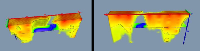
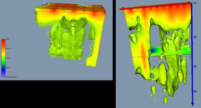
2D & 3D SAMPLING WITH KS-700
MEASUREMENT OF AN UNDERGROUND WATERCOURSE AT A DEPTH OF APPROX. 8M
Tunnel, Visualization with 4m Measuring Point Distance Tunnel, Visualization with 2m Measuring Point Distance (right)